


Trabzon
River network

Author: ÖZDIS HAMDI
If we remember that the most ancient civilizations (Mesopotamia, Egypt, Hittites) were created and grew on the banks of rivers, that people, all their institutions and their goods were transferred to the world and circulated through the rivers, we understand the financial and commercial, as well as the political and cultural importance of rivers. [i] In the Ottoman Empire, which included in its borders the lands of two of the above-mentioned ancient civilizations, river transportation did not develop as much as in America and Europe. While, in 19th century Europe, river and canal transportation was an important and widespread means of transportation for commerce since long, we can say that in the Ottoman Empire river transport was limited. [ii] Additionally, we should note that the issue of river transportation and shipping has not been addressed sufficiently. [iii] For this reason there are only a few mentions of river transportation in Anatolia.
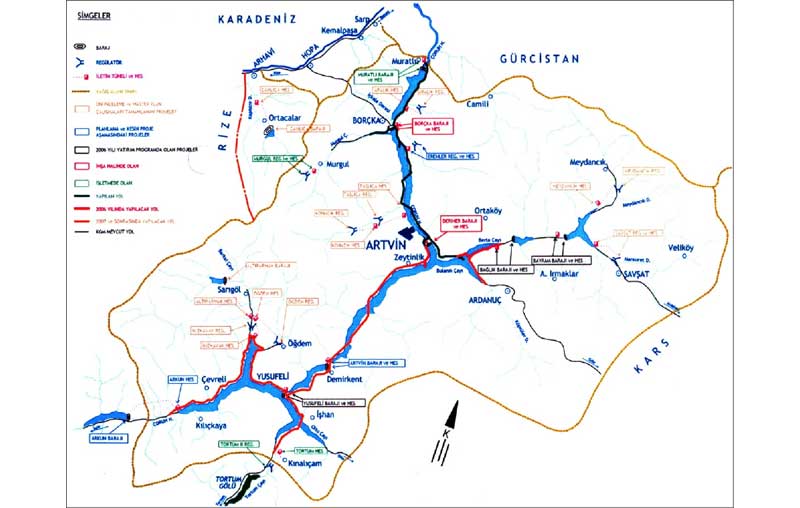
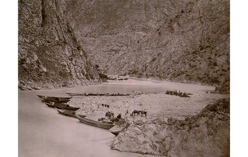
One of these rare cases is the river Çoruh in the province of Trabzon. Despite the fact that our information about transportation on the river Çoruh, that springs in Bayburt, [iv] goes back to E. Çelebi (17th c), we do not have any information for the subsequent centuries. [v] Therefore, an evaluation of the material at hand is inevitable. The first pieces of information about the 466 kilometre-long river Çoruh, 24 km of which on Georgian soil, comes from the famous traveller Evliya Çelebi. From his notes, even though not very detailed, we understand that together with salt, iron, boxwood and honey, men and women prisoners’ trade also took place on Çoruh. However we do not have rich data about the financial circulation. We also learn from Evliya Çelebi’s notes that boats on the Trabzon-Azak route were used for military purposes and that 300 armed Janissaries had boarded 10 Laz-built Menkisile’s.
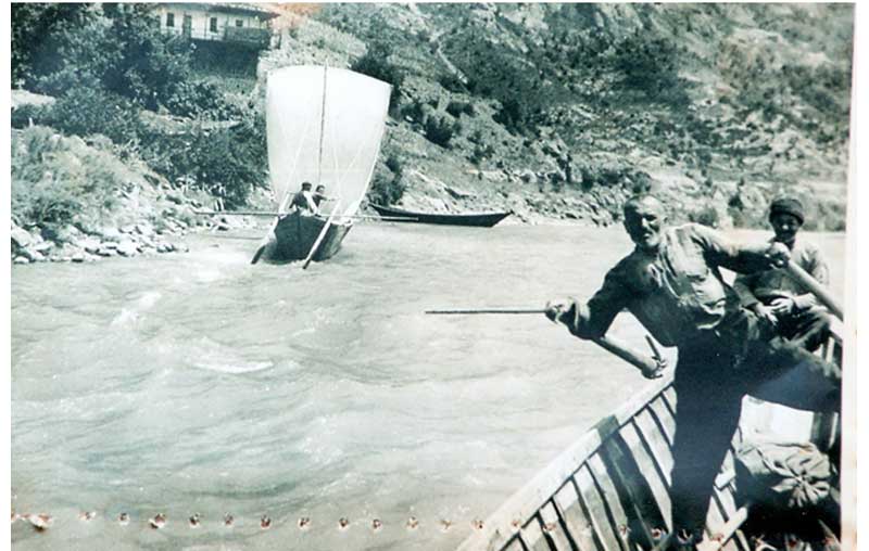
Similar versions of the ships or boats called Menkisile were used in the 19th and 20th centuries and the locals called them “kara-kayık”. These boats in the 19th and 20th centuries could carry fresh fruit like grapes, olives and cherries, as well as all kinds of loads and merchandise like ceramics, logs and walnut stumps [vi] and furniture. Each boat could be loaded with a maximum of 80 baskets and each basket weighed 40 kg. [vii] We can really see from this information that life was very energetic on the banks of the river Çoruh. It should not be forgotten that Çoruh is a very large river basin and that for a while it was called Çoruh province instead of Artvin. [viii] This can be read especially in Caiani’s Borçka Letters. [ix]
Again in Caiani’s letters it is mentioned that even though instructions/a law was issued to regulate the transportation of people and goods by the boatmen on Çoruh in the 1890s, it was not really observed and that this led to accidents. It is also in our knowledge that the Ottoman vali and the mutasarrıf of the time issued directions about the cleanliness of the river, in order to promote a healthier transportation system in Çoruh. [x] It is clear that boating was an important source of revenue for the people living on the banks of Çoruh. Thus, as recorded by an observer of the period, at times, when boat transportation was impossible due to weather conditions, it is clear that the locals suffered substantial financial losses. [xi] Even though there is not any detailed information about the piers or shipyards where the boats were drawn to and the life there, we learn from the period’s official correspondence that in 1864 Kadızade Mehmed Efendi, one of the local notables, built an inn on the river Çoruh. We also know that there were other inns on the banks of Çoruh, called Katip Hanları. [xii]
According to information we get from another group of sources for the 19th century, there were approximately 200 boats [xiii] on Çoruh that carried passengers and loads between Artvin-Batoum, Borçka-Batoum and Artvin-Kabandibi and there were many accidents because of the river’s high flow. The information we have about the duration of these boat trips comes from an observer of the 20th century. Thus, according to the information given by Asim Us, one could go by boat [xiv] from Artvin to Borçka in 2,5 hours and in that period (1945) a passenger paid a fee of 2.5 liras while a load of 2-2,5 tons was charged 30 liras. Ivane Caiani, who worked in the Çoruh valley in the end of the 19th century and who wrote letters about it, notes that each boat could carry 100 passengers for the price of 1 Manat each. Based on this, we can say that one boatman in the 1890’s earned 100 Manat on one journey, whereas in the 1940’s he earned 250 liras. [xv]
[i] Christof Mauch and Thomas Zeller, “Rivers in History and Historiography: An Introduction”, Rivers in History: Perspectives on waterways in Europe and Nort America, University of Pittsburgh Press, Pittsburgh 2008, Digital Research Library, 2011, p.1.
[ii] For the river transportation on the Danube during the Ottoman occupation of Hungary see Sadık Müfit Bilge, “Osmanlı Macaristanında Nehir Ulaşımı”, http://www.academia.edu/3754890/Osmanli Macaristaninda Nehir Ulasimi, 2014.
[iii] Cengiz Orhonlu-Turgut Işıksal, “Osmanlı Devrinde Nehir Nakliyatı Hakkında Araştırmalar Dicle ve Fırat Nehirlerinde Nakliyat”, İstanbul Üniversitesi Edebiyat Fakültesi Tarih Dergisi, XIII, 17-18, 1963, p. 1.
[iv] For a map of the river Çoruh see. Appendix 1. Osman Aytekin, “An Evaluation of Boat Transport on the Coruh River”, The Journal of International Social Research, Vol.6 Issue: 25
[v] Osman Aytekin, “An Evaluation of Boat Transport on the Coruh River”, The Journal of International Social Research, Vol.6 Issue: 25, p. 59- 63.
[vi] In 1935 Prime Minister İsmet İnönü made a journey on one of the boats carrying logs in the river Çoruh. Taner Artvinli, http://www.karalahana.com/makaleler/tarih/coruh-kayiklari.htm
[vii] In the report of English consul Palgrave it is recorded that transportation was possible in the river in the spring and mostly in the summer up until Paşa Bridge at a distance of 40 miles and that loads of between six and even eight tons could be carried. See Report on the Provines of Trebizond, Sivas, Kastemouni, and part of Angora, by Mr. Consul Wgifford Palgrave, January, 1868 FO 881/1592. p. 2,17.
[viii] In a map from the year 1941 that shows the administrative structure, the city of Artvin bears the name of Çoruh. See 1941 yılı Trabzon Vilayeti’nin İdari Taksimatını gösterir harita. İçişleri Bakanlığı Vilayetler İdaresi Genel Müdürlüğü Mülki İdare Taksimatı, 1941.
[ix] İvane Caiani, Borçka Mektupları, transl: Fahrettin Çiloğlu, Sinatle Yayınları, 2002, p. 22.
[x]Prime-ministerial Ottoman Archive (Başbakanlık Osmanlı Arşivi-BOA), MVL 681/1.
[xi] Caiani, p. 7-8.
[xii]BOA, MVL, 681/55.
[xiii] T. Artvinli, “Emektar Çoruh Kayıkları”, Populer Tarih Dergisi,70, (2006), p. 17-19.
[xiv] These boats of Çoruh are 10 metres long and their bottom side is flat. One person at the stern and one at the bow direct the boat with poles in their hands. It is understood that not many differences have occurred in the shape of these boats from the time of Evliya Çelebi to this day. Evliya Çelebi writes that the boats were built from three parts of very large wood, that the bottom part of the boats was flat and, there was also one on each side.
[xv] Of course this is an assessment based on one itinerary. For example another journey could be done from Kabandibi, which is now incorporated in the Georgian borderline, to Batoum in 45 minutes.
References
Archival Sources
The National Archives, Foreign Office (FO)
1868 FO 881/1592. Wgifford Palgrave, Report on the Provines of Trebizond, Sivas, Kastemouni, and part of Angora, by Mr. Consul Wgifford Palgrave, January,
Başabakanlık Osmanlı Arşivi (BOA) Prime-Ministerial Ottoman Archive
MVL, 681/55; MVL 681/1
References
Artvinli, Taner. “Emektar Çoruh Kayıkları [Veteran Çoruh Boats]”, Populer Tarih Dergisi, 70, (2006).
-------------------, http://www.karalahana.com/makaleler/tarih/coruh-kayiklari.htm
Aytekin,Osman. “An Evaluation of Boat Transport on the Coruh River”, The Journal of International Social Research, Vol.6 Issue: 25.
Bilge, Sadık Müfit “Osmanlı Macaristanında Nehir Ulaşımı [River Transport in Ottoman Hungary]”, http://www.academia.edu/3754890/Osmanli Macaristaninda Nehir Ulasimi, 2014.
Caiani, İvane. Borçka Mektupları [Borçka Letters], transl: Fahrettin Çiloğlu, Sinatle Yayınları, 2002
Trabzon Vilayeti Haritası [Map of the Province of Trabzon], İçişleri Bakanlığı Vilayetler İdaresi Genel Müdürlüğü Mülki İdare Taksimatı, 1941.
Mauch, Christof and Thomas Zeller, “Rivers in History and Historiography: An Introduction”, Rivers in History: Perspectives on waterways in Europe and Nort America, University of Pittsburgh Press, Pittsburgh 2008, Digital Research Library, 2011.
Orhonlu, Cengiz -Turgut Işıksal. “Osmanlı Devrinde Nehir Nakliyatı Hakkında Araştırmalar Dicle ve Fırat Nehirlerinde Nakliyat [Studies on River Transport during the Ottoman Period. Transport on the rivers Tigris and Euphrates] ”, İstanbul Üniversitesi Edebiyat Fakültesi Tarih Dergisi, XIII, 17-18, 1963.
Back