


Galatz
River network

Author: ARDELEANU KONSTANTIN
Galaţi is a port on the so called maritime Danube, the river section placed between Brăila and the Black Sea (about 170 kilometres) where the depth of the river allows the navigation of sea-going vessels. Upstream of Brăila, the Danube is divided for a portion into two branches and its depth greatly decreases, below the draughts of maritime ships. A great European river, with of a length of about 2,800 kilometres, the Danube carries a huge quantity of alluviums which are discharged through a Delta into the Black Sea, a closed and almost tide less sea. The Danube Delta has now an approximate surface area of 5,165 square kilometres (including a lagoon in its southern extremity), and its geography has been extremely variable in the past millennia due equally to natural factors and to human activities. The Danube has three main branches through which its waters are discharged into the Black Sea: Chilia (Kilia), Sulina, Sfântul Gheorghe (Saint George). During the ancient times, there was another branch used for navigation, at the termination of which the ancient Greeks founded the famous colony of Histria, whose destiny was fated when the branch began to be silted down at its mouth. During the medieval period, the northern branch of Chilia was used for navigation, and the homonymous citadel became the “key” of the Danube. By the 18th century, when the depth of the Chilia was much reduced, shippers going to Galaţi, Brăila and other Danubian ports started to use the Sulina, the central and the shortest arm of the Danube. It allowed sufficient water for shipping, although especially during the spring its bar greatly increased and became an important hindrance to navigation. Until 1829, when the Danube Delta was Ottoman territory and the Romanian Principalities were not allowed to develop free trading relations with foreign partners, shipping continued in rather traditional conditions. However, a few political changes completely altered this situation. In 1812, Russia annexed Eastern Moldavia or Bessarabia and thus became a riparian country to the Danube. In the following decade she extended her control over the Danube Delta, which she finally annexed in 1829, by the Treaty of Adrianople.
After 1829, when the products of Moldavia and Wallachia were freely exported to European markets and the interest for the cheap agro–pastoral resources of the two provinces increased, Danubian shipping gradually became more difficult, as the depth of the Sulina branch was continuously decreasing, with the Russian authorities’ lack of interest to encourage the trade of Brăila and Galaţi, regarded now as rivals of the great Ukrainian ports in the south of the Russian Empire. From 12 feet in 1840, the depth of the navigable channel diminished, by the 1850s, to about 8 ¼ feet, and in 1853 British diplomats reported that it measured only about 6 feet[1]. Shipping was still possible for smaller vessels, but only after unloading part of the cargo in schleps in order to go beyond the numerous sandbanks of the Lower Danube[2].
Picture 4.2.3_1 The Lower Danube
Source: http://upload.wikimedia.org/wikipedia/commons/8/81/Danube_mouths_1867.JPG
The Sulina Question became a serious object of dispute between Russia and the western cabinets interested to develop Danubian shipping (Austria and Great Britain in the first place), so that at the end of the Crimean War European diplomacy also embarked to solve this issue[3]. By the 1856 Treaty of Paris a European Commission of the Danube (ECD) was created, an international institution based in Galaţi and made up of representatives of the seven signatory powers (Austria, Britain, France, Prussia, Russia, Sardinia, and Turkey). It was to make all necessary technical improvements on the maritime section of the river (between Isaccea and the Black Sea), so as to provide the best shipping conditions for the merchants and ship–owners of all countries. However, these works proved to be more difficult than initially considered, and the ECD was prolonged beyond its initial term settled at Paris (two years). There were also political reasons in this decision, as after its dissolution the administration of navigation on the Danube was to be entrusted to a commission of riparian countries, clearly dominated by Austria[4]. The engineer in chief of the ECD, the British specialist Charles Hartley, studied the hydrographical conditions of the Sulina and St. George branches and in 1858 started provisional works on the Sulina branch, although on the long term those at St. George would have been more advantageous. By way of parallel dykes that directed alluviums at greater depths of the sea, he managed to obtain a navigable depth at Sulina of about 14–15 feet, which offered good conditions to the large ships of that age. He also made technical works along the Sulina branch, getting to a depth of about 20 feet over a navigable breadth of 300 feet. During this period the Commission was also prolonged by international agreements (1866, 1871, 1878, and 1883) and became a solid international institution, which also regulated the juridical and police components of navigation. By the 1878 Treaty of Berlin, when Romanian received the province of Dobrudja (including the Danube Delta), the institution had its own flag and operated independent of the territorial authority (Romania) which controlled the maritime Danube. Hartley as consulting engineer and the new engineer in chief, the Danish Carl Kühl, started in the 1880s a new ambitious plan – that on securing along the entire Sulina branch a navigable depth of minimum 15 feet and thereafter of 20 feet, by removing the difficult bends and by paving the banks in order to avoid erosions and similar phenomena. Until 1902 there were removed 16 bends, and the length of the branch was reduced by 22.7 kilometres, to occupy now an almost straight line of 60.6 km. The minimum depth increased from 14 ¼ feet in 1883 to 17 ¾ feet in 1900. These works also greatly modified the geographical structure of the Danube, and Sulina increased from carrying 7 percent of Danube’s waters to 9 in 1913 and 12 percent in 1921. This increase of debit also led to a growth of carried alluviums. As the average capacity of ships also greatly increased during this period, the deepening of the Sulina mouth to 23–24 feet became a necessity by the early 1900. In order to keep a proper navigable depth, since 1894 dredging was also employed at the mouth and on the Sulina branch[5].
Picture 4.2.3_2 Map of the Sulina Mouth (1856)
Source: http://www.wildernis.eu/chart-room/?nav0=Internationaal&nav1=Danube%20Black%20Sea&nav2=Danube%20Delta&nav3=Sulina
Under these circumstances there were many ships that no longer used the Danube in order to load their cargoes at Brăila and Galaţi, but which did this in the harbour or roadstead of Sulina. A veritable fleet of river schleps was employed to carry grain from the inner Danubian ports to Brăila / Galaţi, and then further to Sulina (or directly to Sulina). Thus, by late 19th and early 20th centuries, commercial circles in the Danubian ports of Brăila and Galaţi considered that Sulina had the same parasitic role in connection to Danubian trade as it had had during the Russian times. The tables below show the development of this trade.
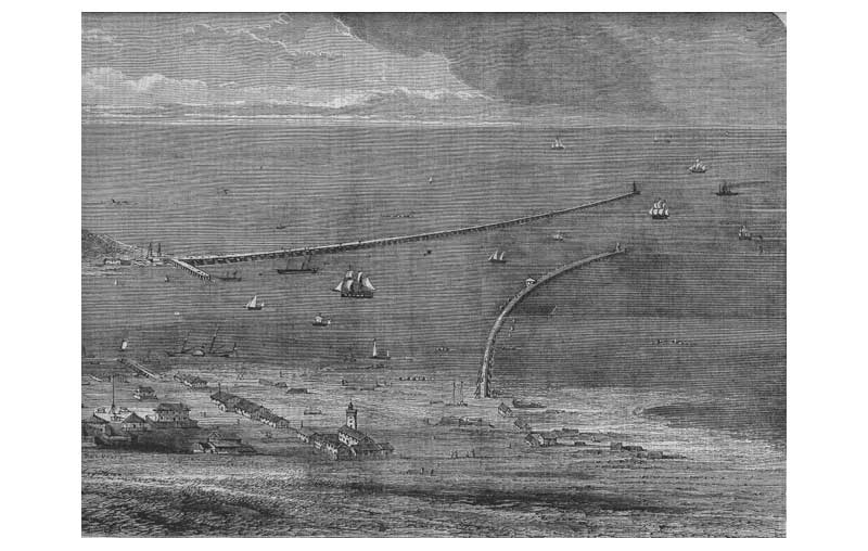
Picture 4.2.3_3 The ECD works at the Sulina Mouth (1861)
Source: http://www.wildernis.eu/chart-room/?nav0=Internationaal&nav1=Danube%20Black%20Sea&nav2=Danube%20Delta&nav3=Sulina
Two other rivers that discharged their waters near Galaţi were also navigable and were employed for shipping. The Pruth (953 km) crossed an area with rich agricultural plains, so there were numerous attempts to make its course navigable. Ulise Negroponte was such an investor, and his shipping company based at Galaţi, “The National Company of Navigation on the Pruth”, employed this river for bringing grain to Galaţi. New projects were drafted in the 1860s, and at high water navigation could be conveniently done. In 1866, by a convention signed at Bucharest, Austria, Russia and Romania founded an International Commission of the Pruth River, similar in purpose to the Danube Commission. It was also based at Galaţi, and in 1870 it started to improve the riverbed of the Pruth, in order to allow its proper navigability.
The “Romanian Shipping Company” introduced in 1893 regular voyagers for the carriage of grain on the Pruth with the steamer “Prutul” and with ten schleps[6].
The Sireth River (535 km) was also navigable along its lower course, being thus employed for bringing cargoes to Galaţi. However, as for a large section it was a rapid stream coming from the Moldavian Carpathians, it was mainly used for carrying timber to Galaţi, as rafts that came along the river[7].
Table 4.2.3_1
Vessels that cleared the maritime, Danubian and river ports of Romania, by categories and tonnage, 1880–1897
|
Year |
Number of ships |
Tonnage (thousand tons) |
||||
|
Total |
Sailing ships |
Steamers |
Romanian |
Foreign |
||
|
1880 |
24,684 |
20,041 |
4,643 |
4,366 |
20,318 |
3,915 |
|
1881 |
26,652 |
20,617 |
6,035 |
5,171 |
21,481 |
4,729 |
|
1882 |
31,887 |
24,897 |
6,990 |
7,734 |
24,153 |
5,566 |
|
1883 |
28,180 |
21,597 |
6,592 |
6,897 |
21,292 |
5,127 |
|
1884 |
25,709 |
19,499 |
6,210 |
6,487 |
19,222 |
4,645 |
|
1885 |
28,481 |
20,019 |
8,462 |
6,389 |
22,092 |
4,814 |
|
1886 |
28,178 |
19,006 |
9,172 |
6,111 |
22,067 |
6,007 |
|
1887 |
30,002 |
18,475 |
11,527 |
6,180 |
23,822 |
7,068 |
|
1888 |
29,101 |
16,832 |
12,269 |
4,946 |
24,155 |
7,590 |
|
1889 |
30,586 |
18,032 |
12,554 |
4,935 |
25,651 |
8,270 |
|
1890 |
29,855 |
17,917 |
11,938 |
4,656 |
25,199 |
7,885 |
|
1891 |
27,476 |
16,442 |
11,034 |
4,595 |
22,881 |
7,156 |
|
1892 |
29,271 |
16,550 |
12,721 |
4,841 |
24,430 |
7,443 |
|
1893 |
33,967 |
20,704 |
13,263 |
4,802 |
29,165 |
9,414 |
|
1894 |
32,898 |
18,103 |
14,795 |
5,003 |
27,895 |
8,919 |
|
1995 |
32,219 |
16,412 |
15,807 |
5,677 |
26,542 |
8,978 |
|
1896 |
33,290 |
16,158 |
17,132 |
6,760 |
26,530 |
9,753 |
|
1897 |
33,520 |
16,048 |
17,472 |
7,294 |
26,226 |
9,214 |
Table 4.2.3_2
Loaded ships, by categories of tonnage, from the maritime and fluvial Romanian ports, 1903–1915[8]
|
Year |
Total |
Sailing ships |
Steamers |
Romanian |
Foreign |
Total |
|
1903 |
10,438 |
5,484 |
4,954 |
2,586 |
7,852 |
4,182 |
|
1904 |
9,184 |
4,772 |
4,412 |
2,662 |
6,522 |
3,520 |
|
1905 |
10,287 |
5,218 |
5,069 |
2,910 |
7,377 |
4,040 |
|
1906 |
12,037 |
5,811 |
6,226 |
3,639 |
8,398 |
4,764 |
|
1907 |
11,191 |
5,894 |
5,297 |
3,195 |
7,996 |
4,450 |
|
1908 |
10,811 |
5,577 |
5,234 |
3,273 |
7,538 |
4,053 |
|
1909 |
10,812 |
5,461 |
5,351 |
3,217 |
7,595 |
4,363 |
|
1910 |
12,722 |
6,302 |
6,420 |
4,159 |
8,563 |
5,443 |
|
1911 |
13,745 |
7,594 |
6,151 |
4,445 |
9,300 |
6,051 |
|
1912 |
12,434 |
6,624 |
5,810 |
4,232 |
8,202 |
4,838 |
|
1913 |
12,110 |
6,652 |
5,458 |
4,242 |
7,868 |
5,160 |
|
1914 |
10,717 |
5,641 |
5,076 |
4,077 |
6,640 |
3,981 |
|
1915 |
5,766 |
3,224 |
2,542 |
4,327 |
1,439 |
1,054 |
|
Year |
Fluvial |
Maritime |
Romanian ships |
Foreign ships |
Travellers (thousands) |
|
1903 |
2,042 |
2,140 |
588 |
3,594 |
302 |
|
1904 |
1,886 |
1,634 |
567 |
2,953 |
346 |
|
1905 |
2,133 |
1,907 |
559 |
3,481 |
328 |
|
1906 |
2,296 |
2,468 |
763 |
4,001 |
408 |
|
1907 |
2,113 |
2,337 |
769 |
3,681 |
396 |
|
1908 |
2,089 |
1,961 |
747 |
3,306 |
470 |
|
1909 |
2,045 |
2,318 |
710 |
3,653 |
685 |
|
1910 |
2,715 |
2,728 |
1,050 |
4,393 |
599 |
|
1911 |
3,141 |
2,910 |
1,236 |
4,815 |
582 |
|
1912 |
2,772 |
2,066 |
1,119 |
3,719 |
579 |
|
1913 |
2,712 |
2,448 |
1,303 |
3,857 |
566 |
|
1914 |
2,289 |
1,702 |
1,102 |
2,879 |
777 |
|
1915 |
1,004 |
50 |
724 |
330 |
643 |
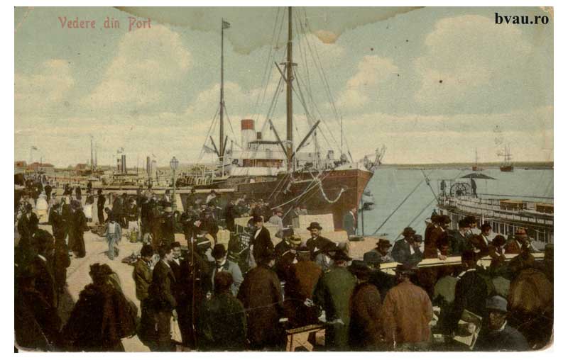
Picture 4.2.3_4 The Port (about 1908)
Source: www.bvau.ro
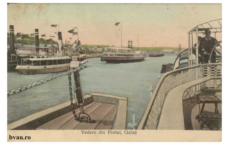
Picture 4.2.3_5 The Port (about 1909)
Source: www.bvau.ro
[1] General remarks on the evolution of the Danube question in international languages in Constantin I. Băicoianu, Le Danube. Aperçu historique, économique et politique, avec un préface par Vintilă I. Brătianu (Paris: Librairie de la Société du Recueil Sirey, 1917) and Henry Hajnal, The Danube. Its Historical, Political and Economic Importance (The Hague: Martinus Nijhoff, 1920).
[2] John Stokes, “The Danube and Its Trade”, Journal of the Society of Arts, 38:1954 (1890), 2 May, 562.
[3] See Constantin Ardeleanu, International Trade and Diplomacy at the Lower Danube. The Sulina Question and the Economic Premises of the Crimean War (1829–1853) (Brăila: Istros Publishing House, 2014).
[4] For the ECD, see La Commission Européenne du Danube et son œuvre de 1856 a 1931 (Paris: Imprimerie Nationale, 1931) and Ştefan Stanciu, România şi Comisia Europeană a Dunării. Diplomaţie. Suveranitate. Cooperare internaţională (Galaţi: Pax Aura Mundi, 2002).
[5] Mémoire sur les Travaux d’Amélioration du Bas-Danube, executés pendant la période 1873 à 1886 par la Commission Européenne (Galaţi: J. Schenk, 1888); Note sur les Travaux Techniques de la Commission Européenne du Danube, 1856 à 1905 (Bucharest: Socec, 1906).
[6] Andrei Oţetea, Pătrunderea comerţului românesc în circuitul internaţional (în perioada de trecere de la feudalism la capitalism) (Bucharest: Editura Academiei Republicii Socialiste România, 1977), 156–157; Îmbunetăţirea navigaţiunei pe Dunăre (1880–1890) şi pe Prut (1887–1890). Importul în România al mărfurilor naţionaliste în Elveţia şi în Olanda (documente presentate Corpurilor Legiutoare în sesiunea ordinară din 1890–91) (Bucharest: Imprimeria Statului, 1891); Leonid Boicu, “Încercări de navigabilizare a râurilor din Moldova în prima jumătate a secolului al XIX-lea”, Anuarul Institutului de Istorie şi Arheologie din Iaşi, 2 (1965), 93–116; Alexandra Duţă, Ştefan Stanciu, “Amenajarea pentru navigaţie a râului Prut la sfârşitul secolului al XIX-lea şi începutul secolului al XX-lea”, Danubius, 12 (1986), 188–191; Paul Păltănea, Istoria oraşului Galaţi de la origini până la 1918, second edition, edited by Eugen Drăgoi (Galaţi: Editura Partener, 2008), vol. II, 36, 42–43, 135–136, 204.
[7] Ibid.
[8] Victor Axenciuc, Evoluţia economică a României. Cercetări statistico-istorice, 1859–1947, vol. I, Industria (Bucharest: Editura Academiei Române, 1992), (Table 335: Ships that cleared loaded, by categories and tonnage, from the maritime and fluvial Romanian ports, during the period 1903–1929).
References
Websites:
Archival sources:
Serviciul Judeţean Galaţi al Arhivelor Naţionale (The National Archives, Galaţi Branch), Comisia Europeană a Dunării (The European Commission of the Danube), files starting with 1856.
Serviciul Judeţean Galaţi al Arhivelor Naţionale (The National Archives, Galaţi Branch), Comisia Mixtă a Prutului (The Mixed Commission of the Pruth), files starting with 1879.
Bibliography:
Ardeleanu, Constantin, International Trade and Diplomacy at the Lower Danube. The Sulina Question and the Economic Premises of the Crimean War (1829–1853) (Brăila: Istros Publishing House, 2014).
Axenciuc, Victor, Evoluţia economică a României. Cercetări statistico–istorice, 1859–1947, vol. I, Industria [Romania’s Economic Evolution. Statistical–Historical Researches, 1859–1947, vol. I, The Industry] (Bucharest: Editura Academiei Române, 1992).
Băicoianu, Constantin I., Le Danube. Aperçu historique, économique et politique, avec un préface par Vintilă I. Brătianu (Paris: Librairie de la Société du Recueil Sirey, 1917).
Boicu, Leonid, “Încercări de navigabilizare a râurilor din Moldova în prima jumătate a secolului al XIX-lea” [Attempts to Secure the Navigability of the Rivers in Moldavia in the First Half of the 19th Century], Anuarul Institutului de Istorie şi Arheologie din Iaşi, 2 (1965), 93–116.
Duţă, Alexandra; Stanciu, Ştefan, “Amenajarea pentru navigaţie a râului Prut la sfârşitul secolului al XIX-lea şi începutul secolului al XX-lea” [The Works for the Navigability of the Prut River at the End of the 19th and in Early 20th Centuries], Danubius, 12 (1986), 188–191.
Hajnal, Henry, The Danube. Its Historical, Political and Economic Importance (The Hague: Martinus Nijhoff, 1920).
Îmbunetăţirea navigaţiunei pe Dunăre (1880–1890) şi pe Prut (1887–1890). Importul în România al mărfurilor naţionaliste în Elveţia şi în Olanda (documente presentate Corpurilor Legiutoare în sesiunea ordinară din 1890–91) [The Improvement of the Navigability on the Danube (1880–1890) and on the Prut (1887–1890] (Bucharest: Imprimeria Statului, 1891).
La Commission Européenne du Danube et son œuvre de 1856 a 1931 (Paris: Imprimerie Nationale, 1931).
Mémoire sur les Travaux d’Amélioration du Bas-Danube, executés pendant la période 1873 à 1886 par la Commission Européenne (Galaţi: J. Schenk, 1888).
Note sur les Travaux Techniques de la Commission Européenne du Danube, 1856 à 1905 (Bucharest: Socec, 1906).
Păltănea, Paul, Istoria oraşului Galaţi de la origini până la 1918 [The History of Galaţi from Its Beginnings to 1918], second edition, edited by Eugen Drăgoi (Galaţi: Editura Partener, 2008).
Stanciu, Ştefan, România şi Comisia Europeană a Dunării. Diplomaţie. Suveranitate. Cooperare internaţională [Romania and the European Commission of the Danube. Diplomacy. Sovereignty. International Cooperation] (Galaţi: Pax Aura Mundi, 2002).
Stokes, John, “The Danube and Its Trade”, Journal of the Society of Arts, 38:1954 (1890).
Back