


Galatz
Portworks

Author: ARDELEANU KONSTANTIN
Customhouses
Warehouses
Wharves
Dredgers
Cranes
Lighthouses
Quarantines, hospitals
The oldest technical works in the harbour of Galaţi are the quays built along the Danube. The old quay was 340 metres long and was constructed in 1851–1853, under the supervision of the Committee for the Town Embellishment. The new quay was 650 metres long and was built between 1872 and 1876 by the municipality, with money from the port fund (0.5 percent tax)[1]. About 1890 the quays in the harbour of Galaţi amounted to 990 metres. There was an unarranged bank (440 metres long) between the two quays, where the headquarters of the shipping agencies were installed. At the same time, the authorities decided to build there a stone riprap and a platform paved with square stones, nine metres wide. The harbour was paved with square stones in 1887 and electric power was available there in 1893[2].
The new customs policy of independent Romania and the intention to abolish the free port privilege led to the necessity of erecting warehouses at Galaţi and Brăila for storing foreign goods in transit[3]. In compliance with the requests of local commercial circles, the Romanian government decided in 1885 to support with the sum of 2,663,000 lei the harbours of Brăila and Galaţi, the provisioned works being the construction of quays, dockyards, grain and general cargo warehouses. The project was drafted by Engineer Anghel Saligny and included the construction of dockyards with quays stretching on a length of 554 metres, supplying a bin of 2,500 tons capacity, a warehouse with an area of 3,000 square meters, and a storehouse for transited goods with an area of 1,000 square meters. The manipulation of goods was to be carried out with two mobile elevators, a floating elevator, four cranes and two hydraulic capstans. The dockyard was 500 metres long on the bottom, 5 metres deep under the most shallow waters and 120 metres minimum width, expanding towards its mouths so that to circumscribe a circle of 192 metres in diameter. The total area of the dockyard at the bottom was of 81,000 square metres and 88,000 at the shallow waters level. The communication with the Danube was done by a 30 meter wide mouth, ended at the headwater with a masonry wall bank going into the river down to the depth of 5.5 metres, and downstream with a wooden scaffold which protected ships against the danger of being thrown by the currents on an incline. The side of the dock towards the warehouses had a quay, while the inclined sides were covered in ripraps and rock fillings, so that all the sides were usable and moor-able. The length of the quay between its extremities was 548 metres, and the usable length was 500 metres. The dockyard was 10.5 metres deep, its bottom being 0.50 metres deeper than the bottom of the Danube at Sulina. The quay was made of a concrete block of 6 metres height, walled up with stone, placed on a network of girders, tying together more than 5,000 posts, 15 metres in height each, which entered the ground through some birch cushions placed on a thick area of 4.5 metres. This entire wooden work was below the water level, so that it was not exposed to damage due to the alternation of humidity and dryness[4].
The grain warehouse looked like a beehive, consisting of 338 bins (cells) or hexagonal compartments made of cement panels and corners tied up with iron. The capacity of some of the bins was 100 kilos (50,000 kilograms), others of 200 kilos (100,000 kg), while others varied from 20 to 200 kilos. The total capacity was 25 million kilograms.
The storehouse for goods was a building made up of five compartments of 20 metres length and 15 metres width, with two storeys each. The goods were lifted either with exterior cranes of 1,500 kg force each or with hydraulic elevators placed in the middle of each compartment and having the same force of 1,500 kg each. The building was accessible from two sides. Its area was 3,000 square meters, out of which 600 metres for circulation and 2,400 metres effectively. As an average of 1,150 kilograms could be stored per square metre, its capacity was 2,760 tons or 11,040 tons per annum. The transit hangar was made of wood, totalling 1,200 square metres. It was used for classifications, customs formalities and sealing of the goods which were not stored in warehouses.
The construction of the dockyards and of the quays was commissioned to a Dutch company, Schram Boutersse Ozingo. The mechanical installations were made by the house Luther of Brunwich and all the buildings were erected with hired labour, with engineers employed by the Romanian State[5]. The works started in the spring of the 1887, and the investments made for the development and systematisation of the harbour amounted to 18,883,866 francs in 1902[6].
The export of industrial goods allowed the beginning of the construction of the railway network in the harbour in 1898, the railways in the docks harbour being connected with the train station for goods.
As the dockyard had become insufficient for the large number of ships calling at Galaţi, Anghel Saligny designed another building in 1908. It was put into operation in 1914. In 1913, the loading of grains was made with three elevators. The government granted a 900,000 lei loan for the expansion of the railway network in the harbour and for the establishment of the train station for goods. It was also at that time that the construction of a great fish hall with refrigerating machines began, a building inaugurated in July 1915[7].
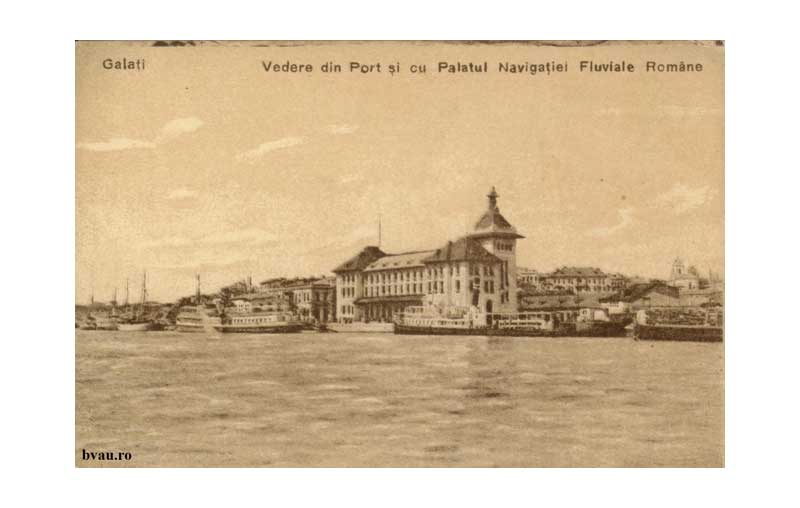
The building of the Navigation Palace was carried out in accordance with architect Petre Antonescu’s designs. It hosted the headquarters of The General Direction of the Romanian Fluvial Navigation Service, The General Inspectorate of Navigation and Ports, The Division of the Hydraulic Service, The Office of Wireless Telegraph, etc[8].
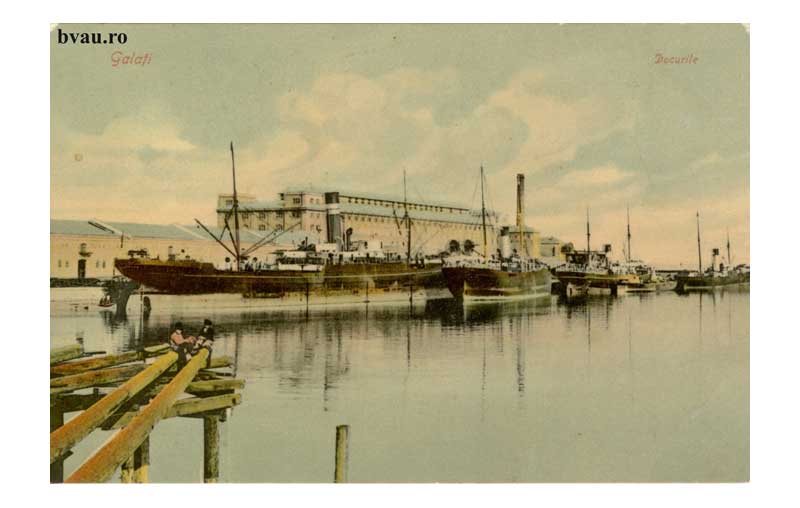
Picture 2.3.2_1 The Dockyard (about 1907)
Source: www.bvau.ro
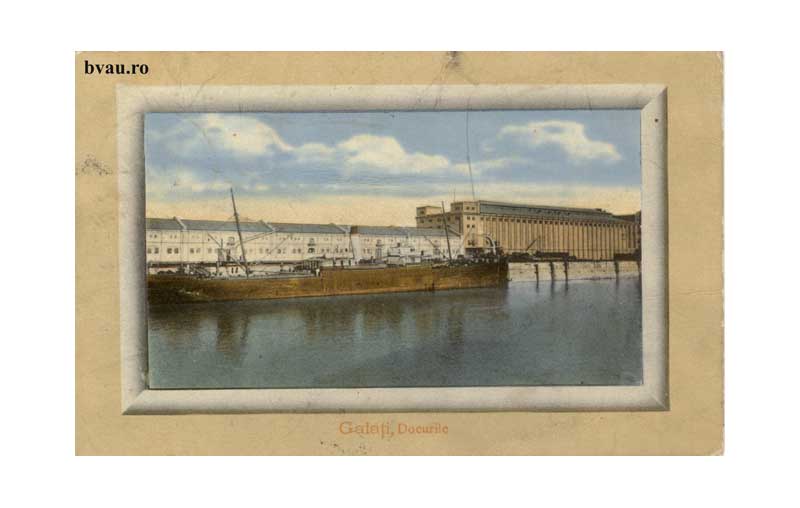
Picture 2.3.2_2 The Dockyard (about 1912)
Source: www.bvau.ro
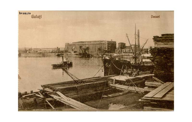
Picture 2.3.2_3 The Dockyard (about 1926)
Source: www.bvau.ro
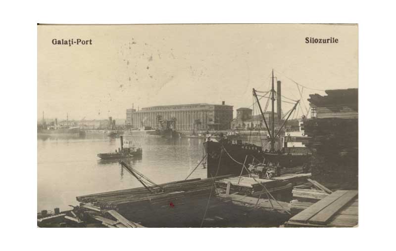
Picture 2.3.2_4 The Silos (about 1927)
Source: www.bvau.ro
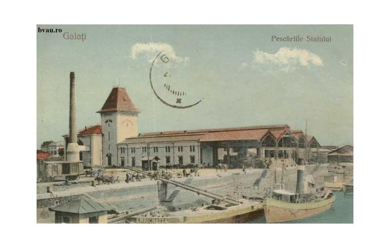
Picture 2.1.2_5 The State Fisheries (about 1930)
Source: www.bvau.ro
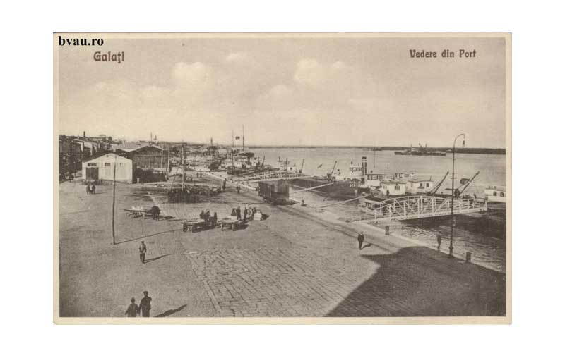
Picture 2.3.2_6 The Harbour (about 1914)
Source: www.bvau.ro
Picture 2.3.2_7 The Harbour (about 1920s)
Source: www.bvau.ro
Picture 2.3.2_8 The Palace of Navigation (about 1926)
Source: www.bvau.ro
[1] Paul Păltănea, Istoria oraşului Galaţi de la origini până la 1918, second edition, edited by Eugen Drăgoi (Galaţi: Editura Partener, 2008), vol. II, 125.
[2] Moise N. Pacu, Cartea judeţului Covurluiu. Note geografice, istorice şi în deosebi statistice (Bucharest: Stabilimentul Grafic I. V. Socecu, 1891), 326–327.
[3] Păltănea, Istoria, II, 189. In 1888 the merchandise were preserved in 88 private entrepots.
[4] Pacu, Cartea, 262–263. A description also at Gh. N. Munteanu–Bârlad, Galaţii (Galaţi: Societate de Editură Ştiinţifică–Culturală, 1927), 103–104.
[5] Pacu, Cartea, 263–267.
[6] Păltănea, Istoria, II, 190.
[7] Ibid.
[8] Docurile şi antrepozitele din Brăila şi Galaţi (Bucharest: Tipografia Curţii Regale F. Göbl Fii, 1890); Valentin Bodea, Monumente istorice şi de arhitectură din oraşul Galaţi din a doua jumătate a secolului al XIX-lea – prima jumătate a secolului al XX-lea, vol. 2 (Galaţi: Pax Aura Mundi, 2011), 80–83.
References
Websites:
The official site of the Dockyards of Galaţi
http://www.romanian-ports.ro/html/port_docuri.html
Archival sources:
Serviciul Judeţean Galaţi al Arhivelor Naţionale (The National Archives, Galaţi Branch), Inspectoratul General al Navigaţiei şi Porturilor Galaţi (The General Inspectorate of Navigation and Ports Galaţi), files starting with 1879.
Serviciul Judeţean Galaţi al Arhivelor Naţionale (The National Archives, Galaţi Branch), Căpitănia Portului Galaţi (Galaţi Habour Master’s Office), files starting with 1884.
Serviciul Judeţean Galaţi al Arhivelor Naţionale (The National Archives, Galaţi Branch), Comisia Europeană a Dunării (European Commission of the Danube), files starting with 1856.
Serviciul Judeţean Galaţi al Arhivelor Naţionale (The National Archives, Galaţi Branch), Primăria oraşului Galaţi (The Municipality of Galaţi), files starting with 1831.
Bibliography:
Bodea, Valentin, Monumente istorice şi de arhitectură din oraşul Galaţi din a doua jumătate a secolului al XIX-lea – prima jumătate a secolului al XX-lea [Historical and Architectural Monuments in the City of Galaţi from the Second Half of the 19th and the First Half of the 20th Centuries], vol. 2 (Galaţi: Pax Aura Mundi, 2011).
Docurile şi antrepozitele din Brăila şi Galaţi [The Dockyards and Entrepots of Brăila and Galaţi] (Bucharest: Tipografia Curţii Regale F. Göbl Fii, 1890).
Pacu, Moise N., Cartea Judeţului Covurlui. Note geografice, istorice şi în deosebi statistice [The Book of Covurlui County. Geographical, Historical and Mainly Statistical Notes] (Bucharest: Stabilimentul Grafic I. V. Socecu, 1891).
Păltănea, Paul, Istoria oraşului Galaţi de la origini până la 1918 [The History of Galaţi from Its Beginnings to 1918], second edition, edited by Eugen Drăgoi (Galaţi: Editura Partener, 2008).
Back