


Galatz
City plans

Author: ARDELEANU KONSTANTIN
During the 19th century the city of Galaţi consisted of two different quarters, clearly delimitated from a geographical and urban perspective: the upper and the lower town. The latter part, caught between the Danube, the Pruth River and the Brateş Lake was the old town, which, although it did not have any mosques and minarets, reminded of a veritable Turkish town. The upper town developed starting with the early 1830s, as a result of the economic prosperity brought about by the port. Consuls, local officials and well-off merchants built stone houses on the hill, in an area that was more systematic than the crowded valley.
A city plan was drafted in early 1830s by engineer Singurov, aiming to align the streets in the old town, a venture that proved impossible. During the next decades, several projects were made for securing a proper development to the new city. In June 1837 Engineer Ignat Rizer concluded a contract with the local authorities to draft the plan of the quarantine, a topographical plan and a plan for the upper town. The first systematisation plan was drafted from the order of Percalab Costache Negri in the early 1850s. It was drafted, according to a European model, by Ignaz Rizer, who did all designs for a surface of 1,221 hectares[1].
In the second half of the 19th century there were drafted several regulations regarding the regime of constructions in Galaţi, so that the new town looked much better than the valley, often affected by floods, as it was the case in 1897[2].
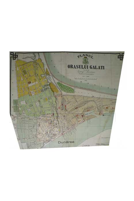
Picture 2.1.1_1 Galaţi City Plan (about 1908)
Source: George Atanasiu, Planul orașului Galați (Galaţi: s.e. 1908)
[1] Paul Păltănea, Istoria oraşului Galaţi de la origini până la 1918, second edition, edited by Eugen Drăgoi (Galaţi: Editura Partener, 2008), vol. I, 343–344, vol. II, 55–56.
[2] Regulament pentru construcţiuni şi alinieri al oraşului Galaţi (Galaţi: Tipografia Aurora, 1893).
References
Websites:
Archival sources:
Serviciul Judeţean Galaţi al Arhivelor Naţionale (The National Archives, Galaţi Branch), Primăria oraşului Galaţi (The Municipality of Galaţi), files starting with 1831.
Serviciul Judeţean Galaţi al Arhivelor Naţionale (The National Archives, Galaţi Branch), Colecţia de planuri (The Collection of Plans), files starting with 1814.
Bibliography:
Pacu, Moise N., Cartea Judeţului Covurlui. Note geografice, istorice şi în deosebi statistice [The Book of Covurlui County. Geographical, Historical and Mainly Statistical Notes] (Bucharest: Stabilimentul Grafic I. V. Socecu, 1891).
Păltănea, Paul, Istoria oraşului Galaţi de la origini până la 1918 [The History of Galaţi from Its Beginnings to 1918], second edition, edited by Eugen Drăgoi (Galaţi: Editura Partener, 2008).
Regulament pentru construcţiuni şi alinieri al oraşului Galaţi [Regulation for Constructions and Alignments of Galaţi City] (Galaţi: Tipografia Aurora, 1893).
Back